Tropical cyclones draw their devastating power from the warmth of the ocean, but many of these storms can be traced back to a desert thousands of miles from where they cause damage.
Written content from Celia Jones via BBC
“If you have ever been in a car crash and remember the screeching of brakes, the impact of the metal scraping, the glass breaking, the groaning of objects smashing,” says Jane Higgins, from her home in the US Virgin Islands. “That is just a titbit of what Irma sounded like.”
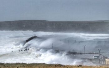
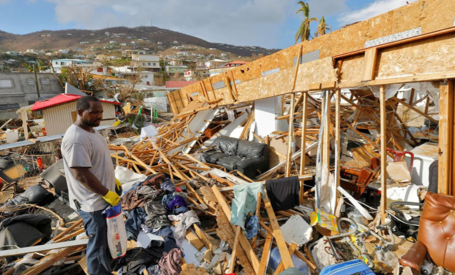
Higgins is one of 51,000 residents on St Thomas who saw their Caribbean island devastated by the powerful Category Five hurricane on 6 September 2017. Four days later Hurricane Irma made a second landfall on the coast of Florida, where the damage it caused made it the costliest hurricane the state had ever experienced, and the fifth-costliest in US history.
The origins of this storm, however, can be traced more than 3,700 miles (5,955km) from the east of Florida. A week earlier, at the tail end of August 2017, a low pressure system had formed above the Cape Verde archipelago off the coast of West Africa. As it moved away from the islands and across the Atlantic, it gathered strength – first becoming a tropical storm and then growing in intensity as it fed off the warm tropical waters until it became a hurricane.
It turns out that about 83% of major hurricanes – categories 3, 4 and 5 – that hit North America share the same birthplace as Irma. Those emerging from Cape Verde are among the most powerful and longest-lived tropical storms. This has led stormwatchers to look closely at the atmosphere above Africa for clues about what might be going on. What is it about the storms emerging from here that makes them so devastating? And is it possible to predict the most powerful hurricanes to give people in their path more time to prepare? (Read more about why we don’t plan better for hurricanes.)
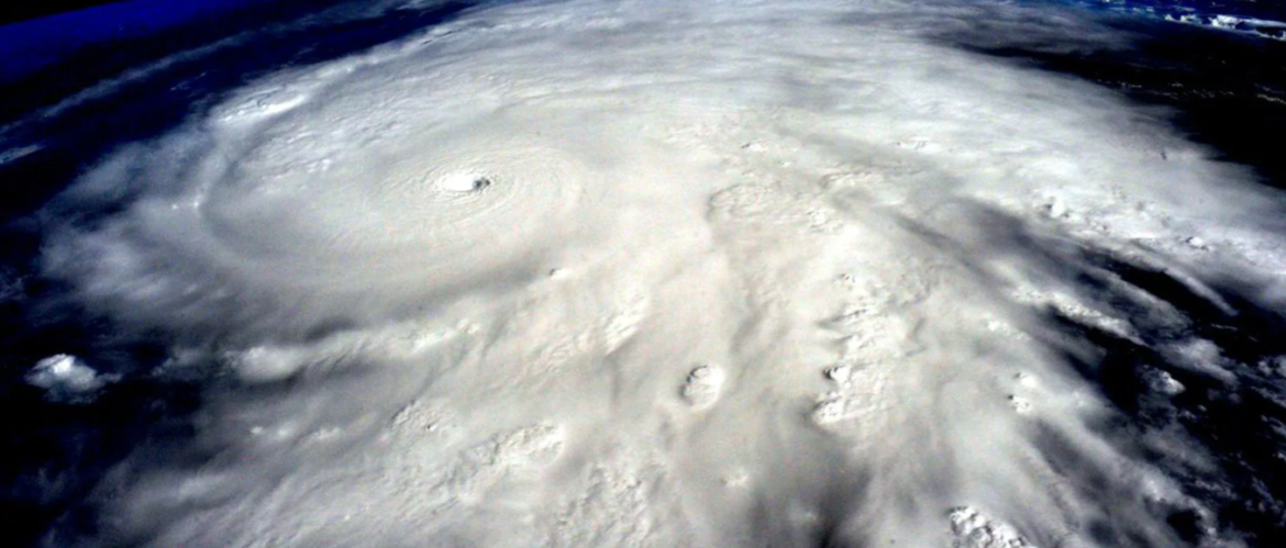
Hurricane Irma was a Category Five hurricane when it hit St Thomas in the US Virgin Islands, bringing widespread destruction (Credit: Alamy)
“Tracking hurricanes from the Cape Verde formation zone gives me and other Caribbean people plenty of time to broadcast preparedness warnings,” Higgins says. She says she is able to recognise early warning signals based on 25 years of island living.
Higgins is one of a number of self-appointed Caribbean island hurricane correspondents who contribute to StormCarib, a network of volunteers who monitor satellite and weather data from across the great swathe of the Atlantic basin for disturbances that may develop into something sinister.
On average, the Atlantic is the stomping ground for around 12 tropical storms a year. Tropical storms start as intense, low-pressure wind systems – or cyclones – that are only named once they have sustained winds that reach 39mph (63km/h). If the wind speeds reach upwards of 74mph (119km/h), they become hurricanes. Only once the maximum winds intensify to 111mph (179km/h), is it given major hurricane status.
You might also like:
- The surprising link between weather and crime
- The storms that shake the world
- The turbines that stand up to typhoons
Typically, the Atlantic sees around six hurricanes a year. But 2020 is no average year – at the time of writing, 25 named tropical storms and nine hurricanes have already formed. After the 2019 hurricane season concluded with Storm Sebastian in November, the World Meteorological Organization’s list of 21 alphabetical names (Q, U, X, Y and Z are excluded) – which are used on a six-year rotation – became exhausted by mid-September. Instead the last four storms have been allocated Greek nomenclature – Alpha, Beta, Gamma and Delta.
Among the nine hurricanes of 2020, four – including the two most powerful storms Laura and Teddy – can be traced back to Africa, where the seeds for their destructive power were first laid. Like all Cape Verde hurricanes, they began as disturbances high in the atmosphere above western Africa, known as African Easterly Waves. These are huge kinks in the stream of air that flows across Africa from east to west.
Among the nine hurricanes of 2020, four – including the two most powerful storms Laura and Teddy – can be traced back to Africa
This stream of air, known as the African Easterly Jet, is driven by the large temperature difference between the enormous expanse of the Sahara Desert and the semi-arid Sahel region to its south.
The Sahara Desert – one of the driest regions on the planet – covers more than 3.3 million square miles (8.5 million sq km) and spans 11 countries in northern Africa. It produces a steady blast of hot, dry air into the atmosphere. “Obviously it’s always hot there, but in the summer it gets really hot,” says Philip Klotzbach, an atmospheric scientist at Colorado State University, who issues seasonal forecasts on the Atlantic hurricane season. The summer heat increases the differences between the hot, dry Sahara and the cooler, wetter Sahel. The more pronounced the temperature gradient, the stronger the jet stream.
As the hot Saharan air rises several kilometres above the surface, it turns southward to meet the cooler air above the Sahel and the Gulf of Guinea. The rotation of the Earth turns this air current westward to create a powerful jet of air across the continent and out into the Atlantic Ocean. “It’s a very strong blow out of the east at 15-20,000ft (4.5-6km),” Klotzbach explains.
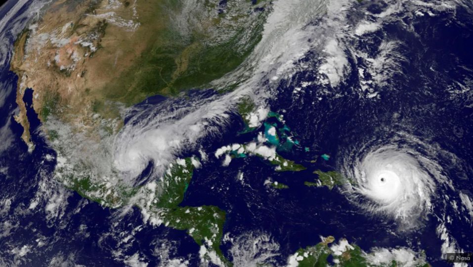
Hurricane Irma was a powerful Cape Verde storm that originated as disruptions in the atmosphere over the African continent (Credit: Nasa)
Warm air forced upwards by mountain ranges in East Africa, such as the Murrah Mountains in the Darfur region of Sudan and the Ethiopian Highlands, creates disturbances in the African Easterly Jet that form enormous wave patterns from north to south. Each of these waves can be around 2,500km (1,553 miles) across.
As this disturbed air moves across the continent, it can either intensify or weaken depending on the temperature and moisture of the land below. This generates clusters of thunderstorms over the west of the continent before they are spat out over the Atlantic Ocean close to Cape Verde.
“These strong thunderstorms feed off it,” says Klotzbach. He pays particular attention to the rain over the Sahel region when he issues Atlantic hurricane forecasts as it can be an indication of what is to come, he says. Enhanced monsoon rainfall suggests a potentially active hurricane season.
Colin Price, an atmospheric scientist at Tel Aviv University, adds that in the Northern Hemisphere’s hot summer months, thunderstorms develop in eastern and central Africa every afternoon like clockwork. “Like turning on the kettle every day,” he says. His research has shown that the formation of these thunderstorms can be used to help predict the intensity of the tropical cyclones that develop from the African Easterly Waves. Lightning activity over east Africa can also serve as an early warning, he and his colleagues have found.
Recent research suggests that 72% of tropical storms in the Atlantic are related to African Eastern Waves
Meteorologists have also discovered that African Easterly Waves can form “trains” where they pass across an area one after another, those preceding leaving behind conditions that cause those trailing to be more intense. These clusters of storms create an extended area of low pressure that leaves the land over Senegal and tends to track past the Cape Verde archipelago.
Recent research suggests that 72% of tropical storms in the Atlantic are related to African Eastern Waves. Not all of these form hurricanes – some head north and peter out while others speed over the warm tropical waters, gather energy and become powerful storms, like hurricane Andrew in 1992 and Frances in 2004.
This is because other ingredients are needed for the waves in the easterly jet to develop into something stronger. “It’s kind of like Goldilocks – a storm needs a perfect combination of many ingredients,” says Rosimar Rios-Berrios, a research meteorologist at the National Center for Atmospheric Research in Colorado. “Unfortunately, all of those are in place this year.”
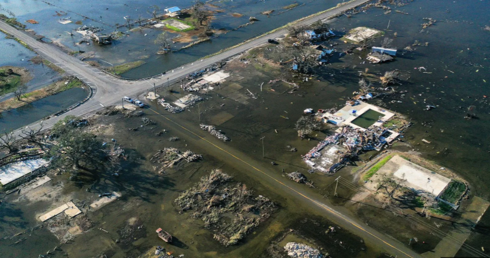
The combined destructive force of Hurricanes Laura and then Delta have left their mark on some coastlines in the US in 2020 (Credit: Getty Images)
A key element in the cocktail is ocean temperature. The hurricane season peaks in September, when the ocean is at its warmest. It must be at least 26C (79F) or above to stoke a storm. Hurricanes thrive off the heat and humidity that rises off warm water, feeding the cyclone with energy.
North easterly trade winds that blow over the ocean typically whip heat away from the surface water and drive the upwelling of cold currents in the Atlantic. But in some years, such as in 2017 when Irma helped make the hurricane season one of the costliest on record, those trade winds are noticeably weaker and lead to higher water ocean temperatures around the tropics.
The winds feeding a tropical cyclone also cannot have what’s called a vertical shear, where there are different wind directions in the bottom of the atmosphere compared to the top, as that can bring the spinning system to a halt. Vertical shear over oceans, Rios-Berrios explains, is caused by wind currents that can span thousands of kilometres. They can be associated with specific weather systems or simply be part of the generate pattern of winds that travel around the world.
Wider climate cycles also play a role in how hurricanes develop. We are currently in La Niña – one half of the El Niño-Southern Oscillation that causes a period of warmer water temperatures at either side of the southern Pacific Ocean. Cooler ocean temperatures in the eastern Pacific means there are weaker winds and less vertical wind shear in the Atlantic basin and Caribbean Sea, allowing groups of storms to organise without much impediment. This goes some way to explain the quantity of named storms that have developed in 2020.
Hurricanes originating from western Africa have the whole stretch of the Atlantic Ocean to intensify over
Time is also important for a hurricane. Hurricanes originating from western Africa have the whole stretch of the Atlantic Ocean to intensify over as they cross towards the Caribbean and the US. It can take several days and even up to a couple of weeks for a cyclone to make its way from Africa to the east coast of the US.
“We might break the record for numbers this year,” Klotzbach says, “but thankfully not severity.” A storm’s severity tends to be measured by accumulated cyclone energy (ACE), which looks at duration and intensity. Many of this year’s storms have been short-lived. Some intensified too close to land, such as Hurricane Laura, or fell apart as they moved north, like Hurricane Omar.
And the Sahara has another hand to play in hurricane formation. Dust storms in the Sahara hurl dry, dusty air into the mid-layers of the atmosphere known as the Saharan Air Layer (SAL), which has been shown to deter a storm’s progress. In the right conditions dust in this layer of air can travel up to 4,900 miles (8,000km) – Florida, Texas and even Central America experience dusty Saharan skies each season. Read more from BBC
Read other severe weather and related stories from News Without Politics

Subscribe to News Without Politics