

On July 13th 2004 a violent tornado tracked for 9.6 miles across Woodford County, with the tornado reaching F4 intensity along a 1-mile stretch between Metamora and Roanoke.
Damage surveys were completed by National Weather Service and Woodford County ESDA personnel on July 14 and 15. Specific details on the tornado’s track follows.
The tornado touched down approximately 1.8 miles north of Metamora, a few hundred yards southeast of the intersection of Illinois Route 89 and county road 1600N. The tornado was initially of F0 (40-72 mph) strength. It moved southeast, and strengthened to F2 intensity (113-157 mph) near the time it reached county road 1300E. It then began a temporary eastward movement for about a half mile, before curving southeast again. It crossed Route 116 just west of the Route 117 junction, and was at F3 strength (158-206 mph) at this point.
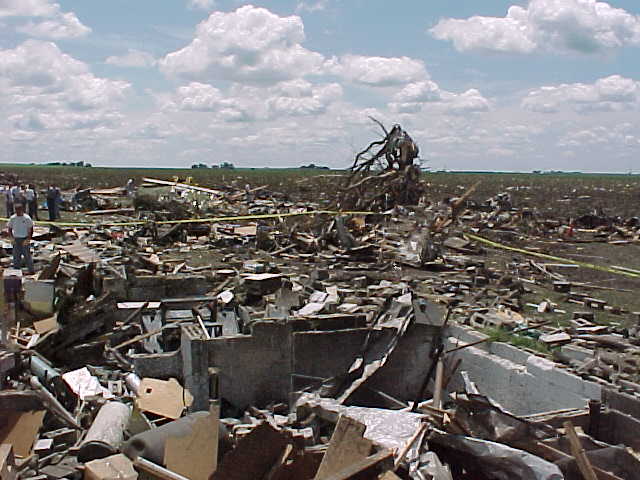
The tornado increased to F4 intensity (approximately 210-240 mph) as it crossed Route 117, demolishing the Parsons Manufacturing Plant at this intersection. Approximately 140 people were in the plant at the time, but all made it to storm shelters in time (approximately 3-5 minutes before the tornado arrived). Steel beams and metal siding from the plant were found approximately 3/4 mile east in a farm field.
From the plant, the tornado continued east, just south of Routes 116/117, affecting 4 farmsteads approximately 1/2 to 1 mile east of the plant. Two of the farmsteads closest to the plant (about 1/2 to 3/4 mile east) had the 2-story houses completely blown away, with only debris remaining in the basements and nearby property. The other two farmsteads had significant damage to the 2-story houses, with outbuildings demolished. The center of the tornado’s track was about 100 yards south of the farmsteads on the south side of the highway.
From the plant to the farmsteads, the storm was F4 intensity. The average width of the tornado during this time was 400 yards, and was close to 1/4 mile wide at times.
At this point, the tornado began to travel in a more east-southeast direction, and caused significant damage to a barn near the intersection of county roads 1300N and 1700E. It caused significant damage at a farmstead at the southeast corner of 1300N and 1800E. The tornado crossed 1300N shortly afterward, and lifted around 2:57 pm about 2.5 miles southeast of Roanoke, at county road 1900E. From NOAA
The tornado was on the ground for approximately 23 minutes.