Trio of storms to parade through West Coast, shut down wildfire season–
A powerful bomb cyclone developed over the northern Pacific…..
The following written content by Alex Sosnowski, AccuWeather senior meteorologist & Meghan Mussoline, AccuWeather meteorologist
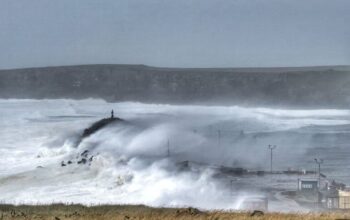
A powerful bomb cyclone developed over the northern Pacific Wednesday night into Thursday morning. The massive storm will be the catalyst that ushers in storm after storm to the West Coast through next Tuesday, unleashing nearly 2 feet of rain in some areas and up to several feet of snow over the mountains. Even though the precipitation is much needed across the drought-stricken region, it could lead to serious flooding, mudslides and significant threats to lives and property.

As the storm train began, gale warnings, high wind warnings and advisories and flash flood warnings were in effect from Northern California through Washington on Thursday.
But the storm won’t be all bad news.
“This rainfall is coming about a month ahead of average and will be very welcome in fighting the remaining fires, particularly in Northern California,” AccuWeather Chief Meteorologist Jon Porter said. “Repeated storms delivering such copious rainfall will have a major effect on the wildfire season – effectively ending the wildfire season from Northern California northward,” Porter added.
Wildfires have burned 1.9 million acres in California in 2021, according to the National Interagency Fire Center. Eight out of the 17 massive fires burning in the United States were all raging in California, as of Thursday.
On the other hand, rainfall will come “too fast and too furious” in some areas with rates of up to 2 inches an hour, according to Porter. The excessive rainfall could result in flash flooding and other dangers like mudslides, particularly in burn scar areas from wildfires that charred the ground in recent years.
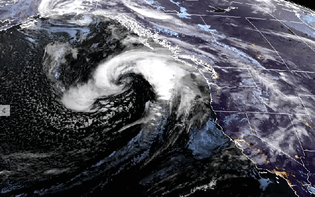
Satellite images showed the storm spinning over the northern Pacific — taking on an almost hurricane-like appearance — just off the coast of western Canada and the Northwest on Thursday. The storm’s central atmospheric pressure plummeted to 28.14 inches of mercury (953 millibars) by Thursday morning — down from 29.12 inches of mercury (986 millibars) on Wednesday and enough to meet the official criteria for bombogenesis, which occurs when a storm’s central pressure drops by at least 0.71 of an inch of mercury (24 millibars) within 24 hours. Read more from AccuWeather.